
What Does the Map of Ancient Egypt Really Tell Us?

Map of the Egyptian empire at its height under Ramesses II, stretching from Nubia to the Levant.
Look at a good map of ancient Egypt and the story jumps out. A thin green river threads the desert. At one point it fans into a delta like an open hand. Capitals cluster where water and routes meet. Cemeteries sit high on dry edges. Temples form a chain along the banks. The map doesn’t just show where things are; it shows why they’re there—and how geography shaped power, belief, and daily life.
The Nile is the engine of the map
Let’s orient ourselves. Upper Egypt is the south (upriver, higher elevation). Lower Egypt is the north (downriver, the Delta). The annual inundation—the seasonal flood that refreshed the soils—created a long, narrow oasis in the desert. If we follow the blue line of the Nile, we are effectively following food, transport, and settlement all at once. Towns and fields hug the floodplain; canals and basins braid the edges. The river writes the script.
That simple reality explains so much. In the Delta, the river splits into multiple branches before reaching the Mediterranean. Those channels made brilliant farmland and a mesh of water routes, but they also shifted over centuries. Ports had to adjust. Some towns thrived while others faded as the river moved. In Upper Egypt, the valley narrows between cliffs. Fewer places to spread out meant a long chain of settlements rather than a web. The map teaches us to read density: many mouths, many harbors in the north; long, linear corridors in the south.
The river also structures time. Scribes and farmers watched the flood’s height the way many of us watch weather apps. High water meant generous harvests; low water meant stress. Once we picture the floodplain as a changing band, it becomes easier to understand why Egypt was administratively careful and ritually repetitive. The landscape demanded coordination, and the art and architecture responded. For the big-picture design lens, see Ancient Egyptian Architecture.
Definition
Nome: an ancient Egyptian province-level district used to organize land, labor, and temples.

The Nile’s broad course supplied water, transport, and fertile soil that sustained Egyptian civilization.
If the river sets the stage, capitals choose the best seats. Memphis grew at the apex of the Delta, the hinge where the single river splits into many mouths. From there, officials could command north–south travel on the Nile and tap east–west desert tracks. The surrounding Memphite necropolis—Saqqara, Giza, Dahshur—runs along the high desert edge, perfectly placed above flood reach but close to the living city. A map makes the logic obvious: administration on the fertile strip, eternity on the dry plateau. For details on locations, cemeteries, and routes, keep open the Memphis site dossier.
Further south, Thebes (Luxor) commands a different kind of crossroads. The river bends. Cliffs form a dramatic western bay. The east bank holds life—city quarters and the great temple complex of Karnak–Luxor—while the west bank shelters the Valley of the Kings and broad funerary terraces. The landscape itself becomes a lesson: sunrise for life, sunset for afterlife. When you trace the processional route on a map, the axis reads like a sentence: approach, assemble, present offerings, return. The clearest single building to feel that orchestration is the Temple of Hatshepsut: Terraces and Cult—cut into the cliff, aligned with the plain.
Capitals also move across history. Memphis dominates the early state; Thebes leads during reunification and empire. Sometimes the capital’s pull is political (who has power now), sometimes religious (which cult centers are ascendant). Either way, the map keeps score. Follow river chokepoints and festival hubs, and you can often predict the winner.

Houses and workshops of Deir el-Medina show the daily lives of the artisans who built the royal tombs.
Nomes: the puzzle grid behind the places
A map of ancient Egypt becomes more useful when we add the nome grid. By the later pharaonic periods, Upper Egypt counted around 22 nomes and Lower Egypt about 20, though the Delta’s tally and shapes shifted as channels silted or were reclaimed. Nomes were not just lines; they were systems: each with a capital town, emblem, local deity, and responsibilities for storage, taxation, labor, and temple support.
Why does this matter for reading a map? Because the nome grid helps us forecast significance. A town at a nome’s center likely hosts administrative buildings and key temples. Roads and canals converge there. In the Delta, more nomes mean shorter distances between hubs—more markets, more harbors, more change. In Upper Egypt, fewer nomes spread along the valley like beads on a string—longer hauls, more reliance on the river.
Add nomes to your map and three things pop:
Routes become obvious. You’ll see where grain and goods likely moved, and where checkpoints mattered.
Festivals become geography. Processions linked nome temples in predictable circuits.
Power becomes legible. Whoever could align nome labor and resources could build faster, campaign farther, and sustain bigger temples.
Once you can read that grid, you’re no longer just looking at dots. You’re seeing an administrative machine tuned to water and seasons.

Map of Lower Egypt showing the Delta region where the Nile branches toward the Mediterranean.
How to “use” the map: three passes that change how you look
Let’s turn this into practice. Open your map and try three quick passes.
1) Trace the river as an index of settlement. Follow from the First Cataract at Aswan to the Delta fan. Notice where the floodplain narrows to a ribbon and where it opens into pockets. Put small flags at bends and junctions. Those are good candidates for ancient towns or checkpoints.
2) Layer capitals and sacred sites. Pin Memphis at the delta apex and Thebes at the southern bend. Now mark cemeteries on the desert edge near Memphis and flip to the western cliffs near Thebes. Draw a line between Karnak and Luxor to sketch the processional axis. You’ve just mapped belief on top of water. Keep the Memphis site dossier nearby for placenames.
3) Add nomes and likely routes. Sketch nome borders lightly (they fluctuate, especially in the Delta). Draw canals or desert tracks that connect nome capitals. What emerges is a choreography of work and worship: where grain moved, where courts met, where statues paraded. A simple paper map turns into a working model of the state. For how those buildings expressed ideas in stone, cross-read Ancient Egyptian Architecture.
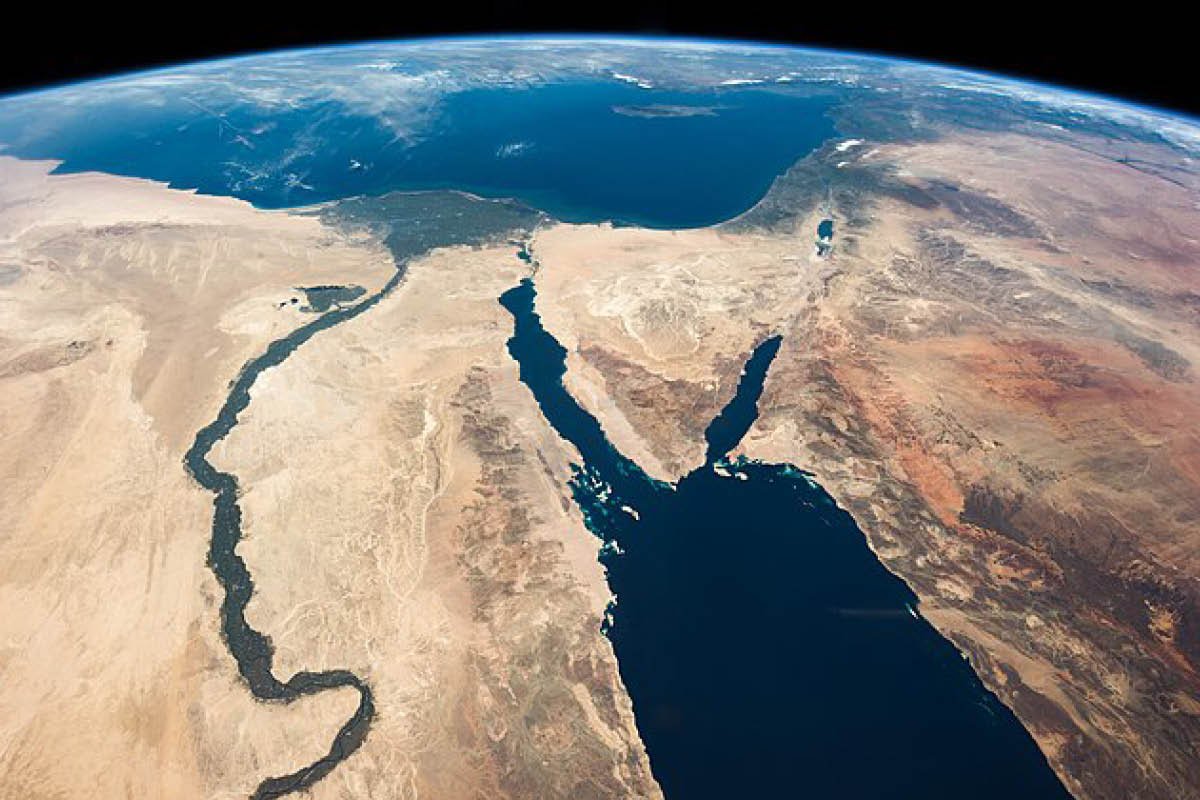
The Nile’s green ribbon and the Sinai desert seen from orbit reveal how geography shaped Egyptian life.
Mini-FAQ
Why are Upper and Lower Egypt “upside down” on a modern map? Because the terms follow river flow, not compass points—Upper is upriver (south), Lower is downriver (north).
Did capitals really move? Yes, across periods. The shifts mirror political reunifications and religious centers gaining prominence. Track chokepoints and cult hubs on a map and the pattern makes sense.
Conclusion: A map that explains decisions
Once we see Egypt as a river-made civilization, the map turns into a set of instructions. Place your capital at a crossroads. Plant cemeteries high and dry. Tie the calendar to festival routes along the banks. Organize the land in nomes that respect water and distance. Geography didn’t passively host Egyptian culture; it authored much of it. Keep this map on hand as you read, and the placement of cities, temples, and tombs will start explaining itself.
You may also like

-
May 2026
20
- May 13, 2026 Roman Colosseum Inside: Seating, Circulation and the Arena Machine May 13, 2026
- May 13, 2026 What Was the Purpose of the Colosseum? Spectacle, Power and Crowd Control May 13, 2026
- May 12, 2026 When Was the Colosseum Built? Date, Construction and Purpose May 12, 2026
- May 12, 2026 Roman Forum: What It Was and How the Space Worked May 12, 2026
- May 11, 2026 How Were Sewers Built in Rome? Sanitation and Urban Infrastructure May 11, 2026
- May 11, 2026 Roman City Planning: How Romans Organized Urban Space May 11, 2026
- May 10, 2026 Roman Amphitheatre: How Rome Built for Mass Spectacle May 10, 2026
- May 10, 2026 Roman Temple Architecture: From Podium to Portico May 10, 2026
- May 9, 2026 Roman Brickwork: Why Brick-Faced Concrete Changed Roman Walls May 9, 2026
- May 9, 2026 Roman Bridges: Why the Arch Made Them Strong May 9, 2026
- May 8, 2026 Segovia Aqueduct: How a Roman Structure Still Dominates the City May 8, 2026
- May 8, 2026 Pont du Gard: Why This Roman Aqueduct Still Feels Impossible May 8, 2026
- May 7, 2026 Aqua Claudia: The Monumental Aqueduct of Rome May 7, 2026
- May 7, 2026 Roman Aqueducts: How Rome Moved Water Across Distance May 7, 2026
- May 6, 2026 Roman Roads: How the Romans Built Routes That Lasted May 6, 2026
- May 6, 2026 Roman Dome: How the Romans Turned Concrete into Space May 6, 2026
- May 5, 2026 Keystone Arch: The Small Stone That Makes Roman Arches Work May 5, 2026
- May 5, 2026 Roman Arch: How the Structure Worked and Why Rome Used It Everywhere May 5, 2026
- May 4, 2026 Roman Concrete: Why It Changed Architecture Forever May 4, 2026
- May 4, 2026 Roman Architecture: Materials, Types and How Roman Building Worked May 4, 2026
-
April 2026
48
- Apr 30, 2026 Etruscan Funerary Art: Why the Tomb Became a Painted Home Apr 30, 2026
- Apr 29, 2026 Sarcophagus of the Spouses: Why This Smiling Couple Became an Icon Apr 29, 2026
- Apr 29, 2026 Tomb of the Reliefs: A House for the Dead in Cerveteri Apr 29, 2026
- Apr 28, 2026 Etruscan Tumulus: How the Burial Mound Worked Apr 28, 2026
- Apr 28, 2026 Necropolis of Tarquinia: Why These Painted Tombs Matter Apr 28, 2026
- Apr 27, 2026 Banditaccia Necropolis: The House-City of the Etruscan Dead Apr 27, 2026
- Apr 27, 2026 Etruscan Necropolis: Why Cities of the Dead Matter Apr 27, 2026
- Apr 26, 2026 Etruscan Tombs: Chamber Tombs, Necropolises and Burial Rituals Apr 26, 2026
- Apr 26, 2026 Etruscan Arch: Why the Gate at Perugia Matters Apr 26, 2026
- Apr 25, 2026 How Did Etruscans Influence Roman Architecture? Temples, Arches and Ritual Space Apr 25, 2026
- Apr 25, 2026 Etruscan Architecture: Temples, Houses and City Gates Explained Apr 25, 2026
- Apr 24, 2026 Etruscan Pottery: Bucchero Ware, Vases and Greek Exchange Apr 24, 2026
- Apr 24, 2026 Etruscan Frescoes: Tomb Wall Paintings, Banquets and the Afterlife Apr 24, 2026
- Apr 23, 2026 Etruscan Art: Style, Materials and Main Themes Apr 23, 2026
- Apr 23, 2026 How Did the Etruscans Influence the Development of Rome? Religion, Power and Urban Life Apr 23, 2026
- Apr 22, 2026 Etruscans Map: Where Was Etruria and Where Did the Etruscans Live? Apr 22, 2026
- Apr 22, 2026 Etruscan Period Explained: Timeline, Phases and Key Dates Apr 22, 2026
- Apr 21, 2026 Who Were the Etruscans? Cities, Art and Why They Matter Apr 21, 2026
- Apr 21, 2026 Venus de Milo: Why This Armless Statue Became So Famous Apr 21, 2026
- Apr 20, 2026 Laocoon and His Sons: Why This Sculpture Feels So Intense Apr 20, 2026
- Apr 20, 2026 Apollo Sauroktonos: Why This Apollo Statue Feels So Different Apr 20, 2026
- Apr 19, 2026 Hermes and the Infant Dionysus: What This Statue Means and Why It Matters Apr 19, 2026
- Apr 19, 2026 Aphrodite of Knidos: Why This Statue Changed Greek Art Apr 19, 2026
- Apr 18, 2026 Greek vs Roman Sculpture: What’s the Difference, Really? Apr 18, 2026
- Apr 18, 2026 Where Is Venus de Milo? Museum, Discovery, and What Happened to It Apr 18, 2026
- Apr 17, 2026 Hellenistic Artists: The Names Behind the Drama of Greek Art Apr 17, 2026
- Apr 17, 2026 Hellenistic Architecture: What Changes After Classical Greece? Apr 17, 2026
- Apr 16, 2026 Alexander the Great and Hellenism: How Greek Culture Spread Apr 16, 2026
- Apr 16, 2026 Hellenistic Meaning: What “Hellenistic” Actually Means Apr 16, 2026
- Apr 15, 2026 Greek Marble Sculpture: Why It Looks So Smooth, Soft, and Alive Apr 15, 2026
- Apr 15, 2026 Greek Marble Sculpture: Why It Looks So Smooth, Soft, and Alive Apr 15, 2026
- Apr 15, 2026 Hellenistic Sculpture: Why It Feels More Emotional and Theatrical Apr 15, 2026
- Apr 14, 2026 Hellenistic Art: Why It Feels More Dramatic Than Classical Art Apr 14, 2026
- Apr 14, 2026 Hellenistic Period: What It Is, Dates, Map, and Why It Matters Apr 14, 2026
- Apr 14, 2026 Late Classical Greek Art: Why Greek Sculpture Starts to Feel More Human Apr 14, 2026
- Apr 13, 2026 Zeus Statue: Identify Zeus by Thunderbolt and Throne Apr 13, 2026
- Apr 12, 2026 Apollo Statue: How to Identify Apollo in Greek Sculpture Apr 12, 2026
- Apr 11, 2026 Athena Statue: How to Identify Her by Armor and Symbols Apr 11, 2026
- Apr 10, 2026 Pediments of the Parthenon: What Each End of the Temple Shows Apr 10, 2026
- Apr 9, 2026 Metopes of the Parthenon: The Four Mythical Battles Explained Apr 9, 2026
- Apr 8, 2026 Parthenon Frieze: How to Read the Procession Scene Apr 8, 2026
- Apr 7, 2026 Statue of Zeus at Olympia: What the Ancient Wonder Was Like Apr 7, 2026
- Apr 6, 2026 Athena Parthenos: What We Know About the Lost Colossal Statue Apr 6, 2026
- Apr 5, 2026 Myron Discobolus: Why This Athlete Defined Classical Motion Apr 5, 2026
- Apr 4, 2026 Polykleitos Doryphoros: Why This Statue Changed Art Forever Apr 4, 2026
- Apr 3, 2026 Optical Illusions of the Parthenon: How They Fool the Eye Apr 3, 2026
- Apr 2, 2026 Parthenon Golden Ratio: Design Rule or Modern Myth? Apr 2, 2026
- Apr 1, 2026 Dimensions of the Parthenon: The Real Numbers Behind the Design Apr 1, 2026
-
March 2026
18
- Mar 31, 2026 Parthenon Meaning: The Secret Message Behind Athena’s Temple Mar 31, 2026
- Mar 30, 2026 Iktinos and Kallikrates: Their Exact Roles on the Parthenon Mar 30, 2026
- Mar 29, 2026 When Was the Greek Parthenon Built? Dates and Timeline Mar 29, 2026
- Mar 20, 2026 Painted Greek Statues: The Originals Were Not All White Mar 20, 2026
- Mar 19, 2026 Parthenon vs Acropolis: Why They Are Not the Same Thing Mar 19, 2026
- Mar 18, 2026 Greek Bronze Statues: Why So Few Survive Today Mar 18, 2026
- Mar 17, 2026 Ancient Greek Statues of Gods: Quick Attribute Guide Mar 17, 2026
- Mar 16, 2026 Female Greek Statues: Drapery, Modesty, Status, Power Mar 16, 2026
- Mar 15, 2026 Male Greek Statues: Why Nudity Signaled Power & Virtue Mar 15, 2026
- Mar 14, 2026 Polykleitos’ Canon: The Rulebook Behind Classical Statues Mar 14, 2026
- Mar 13, 2026 Canon of Proportions: Greek Formula for Ideal Bodies Mar 13, 2026
- Mar 12, 2026 Contrapposto Definition: The Pose That Made Stone Move Mar 12, 2026
- Mar 11, 2026 Greek Statue 101: 6 Visual Clues for Classical Style Mar 11, 2026
- Mar 10, 2026 Golden Age of Greece: Dates, Leaders, and Major Works Mar 10, 2026
- Mar 9, 2026 What Defines the Classical Period? Art Rules Explained Mar 9, 2026
- Mar 8, 2026 Classical Sculpture: How Greeks Made Bodies Feel Alive Mar 8, 2026
- Mar 7, 2026 How to Read Parthenon Sculptures as One Visual Program Mar 7, 2026
- Mar 6, 2026 Why Classical Art Looks Perfect: The Greek Beauty Code Mar 6, 2026
-
January 2026
6
- Jan 6, 2026 Greek Patterns: Meanders, Waves and Palmettes in a Nutshell Jan 6, 2026
- Jan 5, 2026 What Is the Archaic Smile? Why Greek Statues Seem to Grin Jan 5, 2026
- Jan 4, 2026 What Is a Kouros Statue? Quick Guide to Archaic Greek Youths Jan 4, 2026
- Jan 3, 2026 What Is an Amphora Vase? A Quick Guide to This Greek Icon Jan 3, 2026
- Jan 2, 2026 Doric Column: The Simplest Greek Order in Plain Language Jan 2, 2026
- Jan 1, 2026 Athena Symbols in Art: Owls, Olive Trees and the Aegis Jan 1, 2026
-
December 2025
34
- Dec 31, 2025 Greek God Statues: How the Gods Looked in Ancient Greek Art Dec 31, 2025
- Dec 30, 2025 Ancient Greek Religion: Temples, Sacrifices and Belief Dec 30, 2025
- Dec 29, 2025 Peplos Kore: Color and Identity on the Athenian Acropolis Dec 29, 2025
- Dec 28, 2025 Anavysos Kouros: A Fallen Warrior Between Life and Stone Dec 28, 2025
- Dec 27, 2025 Greek Key Pattern: Why the Meander Border Is Everywhere Dec 27, 2025
- Dec 26, 2025 Greek Paintings: Frescoes, Panels and Fragments Explained Dec 26, 2025
- Dec 25, 2025 Ancient Greek Paintings: The Few Images That Survived Dec 25, 2025
- Dec 24, 2025 Greek Black-Figure Pottery: How Greeks Painted in Silhouette Dec 24, 2025
- Dec 23, 2025 Greek Vases: Shapes, Names and How the Greeks Used Them Dec 23, 2025
- Dec 22, 2025 Greek Pottery: How Everyday Vases Became Story on Surface Dec 22, 2025
- Dec 21, 2025 Ionic Columns: How They Differ from Doric and Corinthian Dec 21, 2025
- Dec 20, 2025 Types of Columns: Doric, Ionic and Corinthian for Beginners Dec 20, 2025
- Dec 19, 2025 Ancient Greek Fashion: What People Actually Wore Every Day Dec 19, 2025
- Dec 18, 2025 Ancient Greek Houses: How People Lived Behind the Temples Dec 18, 2025
- Dec 17, 2025 Ancient Greek Map: Main Ancient Cities and Sanctuaries Dec 17, 2025
- Dec 16, 2025 Ancient Greek City-States: How the Polis Shaped Art Dec 16, 2025
- Dec 15, 2025 Ancient Greek Structures: Temples, Theatres and City Walls Dec 15, 2025
- Dec 14, 2025 Greek Architecture: Columns, Temples and Theatres Explained Dec 14, 2025
- Dec 13, 2025 Ancient Greek Sculpture: From Archaic Smiles to Classical Calm Dec 13, 2025
- Dec 12, 2025 Ancient Greek Art: A Guide from Geometric to Hellenistic Style Dec 12, 2025
- Dec 11, 2025 Archaic Period in Greek Art: Geometric Schemes and Full Figures Dec 11, 2025
- Dec 10, 2025 Geometric Art in Greece: Lines, Patterns and Tiny Horses Dec 10, 2025
- Dec 9, 2025 Greek Temples: How the Ancient Greeks Built for Their Gods Dec 9, 2025
- Dec 8, 2025 Archaic Greek Sculpture: Kouroi, Korai and the First Art Forms Dec 8, 2025
- Dec 7, 2025 Linear A and Linear B: The Scripts of the Aegean Dec 7, 2025
- Dec 6, 2025 Cyclopean Masonry in Two Minutes Dec 6, 2025
- Dec 5, 2025 What Is a Megaron? Dec 5, 2025
- Dec 5, 2025 Theseus and Ariadne: How a Bronze Age Story Survives in Greek and Modern Art Dec 5, 2025
- Dec 4, 2025 From Minoans to Mycenaeans: What Changes in Art and Power? Dec 4, 2025
- Dec 3, 2025 The Lion Gate at Mycenae: Architecture, Symbol and Power Dec 3, 2025
- Dec 3, 2025 Mycenaean Architecture: Megaron, Citadel and Cyclopean Walls Dec 3, 2025
- Dec 2, 2025 Who Were the Mycenaeans? Fortress-Cities and Warrior Kings Dec 2, 2025
- Dec 1, 2025 Minoan Wall Paintings: Bulls, Dancers and Island Landscapes Dec 1, 2025
- Dec 1, 2025 Religion in Minoan Crete: Goddesses, Horns and Sacred Peaks Dec 1, 2025
-
November 2025
36
- Nov 30, 2025 The Labyrinth and the Minotaur: From Knossos to Later Greek Art Nov 30, 2025
- Nov 30, 2025 Bull-Leaping Fresco: Sport, Ritual or Propaganda? Nov 30, 2025
- Nov 30, 2025 How Minoan Palaces Worked: Knossos, Phaistos and the “Labyrinth” Idea Nov 30, 2025
- Nov 30, 2025 Who Were the Minoans? Crete, Palaces and the First Thalassocracy Nov 30, 2025
- Nov 29, 2025 Daily Life in the Cyclades: Homes, Graves and Sea Routes Nov 29, 2025
- Nov 28, 2025 The Plank Idols: How to Read a Cycladic Figure Nov 28, 2025
- Nov 27, 2025 Why Are Cycladic Idols So “Modern”? Minimalism Before Modern Art Nov 27, 2025
- Nov 26, 2025 What Is Cycladic Art? Marble Idols, Graves and Meaning Nov 26, 2025
- Nov 25, 2025 Bronze Age Ancient Greece: From Cycladic to Mycenaean Art Nov 25, 2025
- Nov 24, 2025 Aegean Art Before Greece: Cycladic, Crete and Mycenae Explained Nov 24, 2025
- Nov 16, 2025 Eye of Ra vs Eye of Horus: 5 Key Differences Nov 16, 2025
- Nov 15, 2025 Mummification Meaning: purpose, symbols, tools Nov 15, 2025
- Nov 14, 2025 Memphis: Site Dossier and Early Capital Nov 14, 2025
- Nov 14, 2025 The First Dynasty of Egypt: a Complete Framework Nov 14, 2025
- Nov 13, 2025 How Ancient Egyptian Architecture Influenced Greece and Rome Nov 13, 2025
- Nov 12, 2025 7 Facts That Make Tutankhamun’s Mask a Masterpiece Nov 12, 2025
- Nov 12, 2025 A Visual Framework for Studying Egyptian Sculptures Nov 12, 2025
- Nov 11, 2025 Inside the Pyramids of Giza: chambers explained Nov 11, 2025
- Nov 10, 2025 Philae Temple: Isis Sanctuary on the Nile Nov 10, 2025
- Nov 10, 2025 Why Ancient Egyptian Houses Were Surprisingly Advanced Nov 10, 2025
- Nov 9, 2025 5 Hidden Details in the Temple of Hathor Stairs? Nov 9, 2025
- Nov 9, 2025 What Happened to the Great City of Memphis? Nov 9, 2025
- Nov 8, 2025 Why Did Egyptians Build a Pyramid Inside a Pyramid? Nov 8, 2025
- Nov 7, 2025 5 Things to Know Before Visiting Edfu Temple Nov 7, 2025
- Nov 7, 2025 Why Egyptian Wall Paintings Still Dazzle Historians Nov 7, 2025
- Nov 6, 2025 Ancient Egyptian Art and Culture: a Beginner’s Guide Nov 6, 2025
- Nov 5, 2025 7 Mysteries Hidden in the Mortuary Temple of Hatshepsut Nov 5, 2025
- Nov 5, 2025 Top 5 Largest Egyptian Statues: Names and Places Nov 5, 2025
- Nov 3, 2025 How Was the Pyramid of Giza Constructed Without Modern Tools? Nov 3, 2025
- Nov 3, 2025 Is Abu Simbel Egypt’s Most Impressive Temple? Nov 3, 2025
- Nov 3, 2025 What Does the Map of Ancient Egypt Really Tell Us? Nov 3, 2025
- Nov 2, 2025 Lamassu Pair, Khorsabad: Why five legs? Nov 2, 2025
- Nov 2, 2025 Ishtar Gate Lion Panel: Why one lion mattered? Nov 2, 2025
- Nov 2, 2025 Why do Sumerian votive statues have big eyes? Nov 2, 2025
- Nov 1, 2025 Dur-Sharrukin: Why build a new capital? Nov 1, 2025
- Nov 1, 2025 Standard of Ur: War and Peace in Inlay Nov 1, 2025
-
October 2025
32
- Oct 31, 2025 Dying Lion Relief, Nineveh: Why so moving? Oct 31, 2025
- Oct 31, 2025 Did the Hanging Gardens of Babylon exist? Oct 31, 2025
- Oct 30, 2025 Groom Leading Horses: What does it depict? Oct 30, 2025
- Oct 30, 2025 How did the first cities form in Mesopotamia? Oct 30, 2025
- Oct 29, 2025 What was Etemenanki, the Tower of Babel? Oct 29, 2025
- Oct 29, 2025 Standard of Ur: What do War and Peace show? Oct 29, 2025
- Oct 28, 2025 Foundation Figure with Basket: What is the ritual? Oct 28, 2025
- Oct 28, 2025 Mask of Warka (Uruk Head): The First Face Oct 28, 2025
- Oct 27, 2025 Eannatum Votive Statuette: Why hands clasped? Oct 27, 2025
- Oct 27, 2025 What are the famous Assyrian reliefs? Oct 27, 2025
- Oct 26, 2025 Gudea Statue: Why use hard diorite? Oct 26, 2025
- Oct 26, 2025 Bas-relief vs high relief: what’s the difference? Oct 26, 2025
- Oct 25, 2025 Ishtar Gate’s Striding Lion: Power in Blue Oct 25, 2025
- Oct 25, 2025 Vulture Stele: What battle and gods are shown? Oct 25, 2025
- Oct 24, 2025 What does the Stele of Hammurabi say? Oct 24, 2025
- Oct 24, 2025 Temple of Inanna, Uruk: What remains today? Oct 24, 2025
- Oct 23, 2025 Etemenanki: What did it look like? Oct 23, 2025
- Oct 23, 2025 What is Mesopotamian art and architecture? Oct 23, 2025
- Oct 22, 2025 Why is the Ishtar Gate so blue? Oct 22, 2025
- Oct 22, 2025 Ishtar Gate: Which animals and why? Oct 22, 2025
- Oct 21, 2025 Stele of Hammurabi: What does it say and show? Oct 21, 2025
- Oct 21, 2025 Lamassu of Khorsabad: The Five-Leg Illusion Oct 21, 2025
- Oct 20, 2025 Ziggurat of Ur: What makes it unique? Oct 20, 2025
- Oct 20, 2025 What is a ziggurat in Mesopotamia? Oct 20, 2025
- Oct 13, 2025 Su Nuraxi, Barumini: A Quick Prehistory Guide Oct 13, 2025
- Oct 12, 2025 Nuraghi of Sardinia: Bronze Age Towers Explained Oct 12, 2025
- Oct 10, 2025 Building With Earth, Wood, and Bone in Prehistory Oct 10, 2025
- Oct 8, 2025 Megaliths Explained: Menhirs, Dolmens, Stone Circles Oct 8, 2025
- Oct 6, 2025 Homes Before Houses: Huts, Pit Houses, Longhouses Oct 6, 2025
- Oct 5, 2025 Prehistoric Architecture: From Shelter to Symbol Oct 5, 2025
- Oct 3, 2025 Venus of Willendorf: 10 Fast Facts and Myths Oct 3, 2025
- Oct 1, 2025 Hand Stencils in Rock Art: What, How, and Why Oct 1, 2025
-
September 2025
5
- Sep 29, 2025 Prehistoric Sculpture: Venus Figurines to Totems Sep 29, 2025
- Sep 28, 2025 From Hands to Geometry: Reading Prehistoric Symbols Sep 28, 2025
- Sep 26, 2025 Petroglyphs vs Pictographs: The Clear Field Guide Sep 26, 2025
- Sep 24, 2025 How Rock Art Was Made: Tools, Pigments, and Fire Sep 24, 2025
- Sep 22, 2025 Rock Art: Prehistoric Marks That Changed Reality Sep 22, 2025