Etruscans Map: Where Was Etruria and Where Did the Etruscans Live?
A map like this makes Etruria easier to grasp as a network of city-states, not a single unified kingdom.
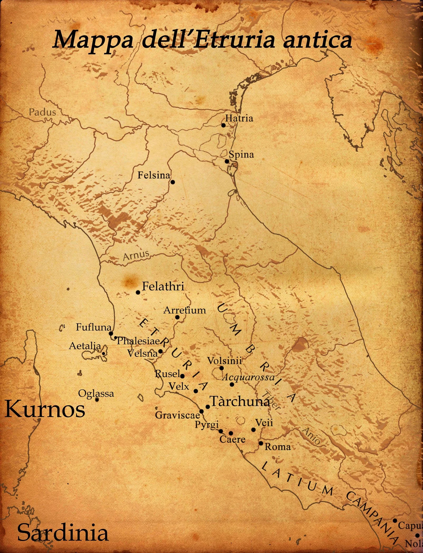
If you want to understand the Etruscans, the map is one of the best places to start. The Etruscans lived in central Italy, in a region the ancient world called Etruria, and that geography helps explain almost everything else: their cities, their trade, their wealth, and their influence on early Rome. In modern terms, Etruria covered much of Tuscany, plus parts of Lazio and Umbria.
That may sound simple, but the map matters more than it first seems. The Etruscans were not scattered randomly across Italy. They were concentrated in a strategic zone between rivers, hills, coastlines, and trade routes. Their cities were close enough to form a cultural network, yet independent enough to develop strong local identities. Once you place Etruria on the map, the whole story becomes easier to read.
Etruria was in central Italy, and that location gave the Etruscans unusual strength
Yes, Etruria was in central Italy, and that central position was a major advantage. The Etruscan heartland stretched roughly between the Arno River to the north and the Tiber River to the south. That meant the Etruscans were close to fertile land, mineral resources, inland routes, and the Tyrrhenian Sea, the stretch of Mediterranean water along Italy’s western coast.
This helps answer several beginner questions at once. If you are asking where was Etruria, the answer is central western Italy. If you are asking where is Etruria located, the answer is that it corresponds broadly to modern Tuscany, northern Lazio, and western Umbria. And if you are asking where did the Etruscans live, the answer is that they lived mainly in that core region, while also expanding their influence beyond it at different points in their history.
That location made Etruria more than a quiet inland zone. It connected the Etruscans to sea trade, to neighboring Italic peoples, and to the wider Mediterranean world. It also placed them near later Rome, which helps explain why contact, rivalry, and influence between the two cultures became so important.
If you want the broader cultural picture behind that geography, who were the Etruscans gives the fuller introduction. This article focuses on place, but place only matters because it shaped a real civilization.
The Etruscans lived in cities, not in one unified kingdom
This is one of the most important things the map shows. The Etruscan world was not one single state with one capital. It was a network of city-states, each with its own territory, political life, elites, and religious traditions. That makes the Etruscan map look less like a solid block and more like a constellation of important urban centers.
Among the best-known Etruscan cities were Tarquinia, Cerveteri, Veii, Vulci, Chiusi, Volterra, Perugia, Populonia, and Arezzo. Some were inland. Some were closer to the coast. Some became especially important because of trade, others because of religious prestige, agricultural control, or access to metal resources. Together, they formed the core of Etruscan civilization.
This urban pattern matters because it explains both Etruscan strength and Etruscan weakness. Their cities created a dense and sophisticated cultural world, but they were politically separate. That helped local identity flourish, yet it also made unified resistance harder when Rome expanded. So the map is not just about location. It is also about political structure.
You can see this more clearly if you connect geography to chronology. The Etruscan period was not static. Etruscan power grew, shifted, and contracted over time, and the map changed with it.
Coastlines, rivers, and resources made Etruria economically powerful
The Etruscans did not become important by accident. Their territory gave them access to resources that helped fuel urban growth and long-distance exchange. Etruria was rich in agricultural land, but also in mineral wealth, especially in areas linked to metal extraction and trade. This mattered enormously in the ancient world, where metal meant tools, weapons, prestige objects, and economic power.
The coastline was just as important. Etruscan access to the Tyrrhenian Sea connected them to maritime trade with other parts of the Mediterranean, including Greek and Phoenician networks. Ports and coastal settlements helped move goods, people, and ideas. That is one reason Etruscan culture became so visually rich and outward-looking. Imported objects, styles, and technologies did not arrive in a vacuum. They arrived because Etruria was geographically well positioned to receive and transform them.
Rivers also mattered. They helped organize territory, movement, and agricultural life. Meanwhile, many Etruscan settlements were established on raised plateaus or defensible heights, which offered both protection and visibility over the landscape. This combination of fertile land, defensible sites, mineral resources, and sea access made the region unusually strong.
So when someone looks at an Etruscans map, they are not just locating an ancient people. They are seeing the physical conditions that helped produce one of the most powerful cultures of pre-Roman Italy.
Certain places on the map matter more than others, and Cerveteri is one of them
Some Etruscan sites are especially important because they preserve the civilization so vividly. Cerveteri, ancient Caere, is one of the clearest examples. It was a major Etruscan city near the coast, and its famous cemetery, the Banditaccia Necropolis, shows just how developed Etruscan funerary culture and urban planning had become.
This is where geography becomes almost architectural. The necropolis is not just a field of graves. It is a planned landscape of tombs, pathways, and burial structures that can feel almost like a city of the dead. That makes it one of the best places for understanding how the Etruscans imagined family, memory, and status in spatial terms.
If you want to see how one site can reveal the larger map, Banditaccia Necropolis is a useful next step. It shows how an Etruscan city was tied not only to trade and territory, but also to ritual landscapes just beyond the urban core.
Tarquinia is another crucial place on the map, especially for painted tombs. Veii matters because of its relation to Rome. Populonia matters because of metalworking and its coastal position. In other words, the Etruscan map is not flat. Different sites tell different parts of the story.
The Etruscan map also makes more sense when you compare it to the Greek world
This comparison is especially useful for beginners. Ancient Greece was not one solid nation-state either. It was a world of regions, islands, colonies, and city-states connected by language, religion, and exchange. The Etruscan world worked differently, but the comparison helps because both cultures developed through networks rather than through one centralized political unit.
Looking at an ancient Greek map alongside the Etruscan one can make the Mediterranean setting much clearer. It shows why contact between Greeks and Etruscans mattered so much. The sea was not a barrier. It was a route. Ideas, objects, myths, and artistic forms moved across it constantly.
This is also why Etruria should not be imagined as isolated. It was local and connected at the same time. That double condition helps explain a lot about Etruscan art and identity. Their cities were rooted in Italian soil, but their culture was shaped through active engagement with a wider world.
Why does the map matter so much? Because geography explains the civilization’s rise
The map matters because it turns abstract history into something visible. It shows why the Etruscans emerged where they did, why their cities became wealthy, why they were able to trade widely, and why they came into such close contact with Rome. It also shows why their world was strong but never fully unified.
A beginner-friendly way to remember it is this: Etruria was central, connected, and resource-rich. Those three qualities help explain the rise of the Etruscans better than any isolated date. Their cities grew in a region that offered access to land, metals, coastlines, and routes. Geography did not determine everything, but it created the conditions in which Etruscan civilization could flourish.
Conclusion
Place the Etruscans on the map, and their history becomes much easier to understand. Etruria was the central Italian region where the Etruscans built their city-based civilization, mainly across modern Tuscany, Lazio, and Umbria. Its coastlines, rivers, hills, and resources helped generate wealth, exchange, and regional power. That is why the map is not just background information. It is one of the clearest keys to understanding who the Etruscans were and why they mattered.

FAQ
Where was Etruria?
Etruria was in central Italy, mainly in what is now Tuscany, with parts of Lazio and Umbria.
Where did the Etruscans live?
They lived mainly in Etruria, in a network of major city-states such as Tarquinia, Cerveteri, Veii, Vulci, and Chiusi.
Is Etruria the same as Tuscany?
Not exactly, but Tuscany formed a large part of ancient Etruria. Etruria also extended into parts of modern Lazio and Umbria.
Why was Etruscan geography important?
Because it gave the Etruscans access to fertile land, mineral resources, defensible sites, and sea trade routes.
Were the Etruscans only in central Italy?
Their core homeland was central Italy, but at their height their influence extended farther north and south beyond Etruria itself.
Sources and Further Reading
The Metropolitan Museum of Art — “Etruscan Art” (2004)
Smarthistory — “The Etruscans, an Introduction” (2015)
Encyclopaedia Britannica — “Etruscan” (2024)
UNESCO World Heritage Centre — “Etruscan Necropolises of Cerveteri and Tarquinia” (2004)
You may also like